|
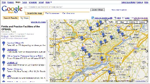
GREATER PHILADELPHIA
MABL
FIELD
DIRECTIONS
Scroll Down For Fields Listed
In Alphabetical Order
or
Click
here to use the GPMABL Google Map
to view the route and create your own directions


Cardinal O’Hara
Take I-95, or 276 depending on
where you live to 476.
From I-95 you will take 476 North.
From 276 you will take 476 South.
Heading towards Springfield, Delaware County.
Take 476(blue rt) to exit #5/US-Rt.1 onto Media Bypass toward Springfield.
Take ramp toward Sproul Road.
Turn left on W. Sproul Road.
W.
Sproul Road becomes New Sproul Road.
New Sproul Road becomes Sproul Road.
(All within 1 mile this happens -- look for the KFC/Taco Bell, after that the school is after the
next light ahead).
Cardinal O'Hara High School is on the right at 1701 Sproul Road.

Cheltenham
From South:
North on Roosevelt Blvd.
Left onto Rising Sun Avenue
After 2.5 miles, left onto Martins Mill Road
500 ft. past 1st light (Oakley St.), make a left onto Woodland Street (near a
church)
Park at the top lot
From North:
South on Roosevelt Blvd.
Right onto Cottman Avenue
After 3 miles, left onto Central Avenue
After 1 mile, left at light onto Old Soldiers
Road
After 400 ft., right onto Woodland Street (near
a church)

Clifton Heights (Pietropola Memorial Field)
From I-76 take 476 S From I-95 take
476 N
Take 476 to Rt 1 North (Exit 5)
Follow Rt 1 North approximately 1.5 miles
Turn Right onto W. Springfield Rd. (will turn into N. Springfield Rd)
Stay on Springfield Rd. for approximately 2.8 miles.
The field is on the left hand side at the top of the hill.
210 N
Springfield Rd Clifton Heights, PA 19018

Deptford High School Field
Cross Walt Whitman or Ben
Franklin Bridge
Follow either bridge to route 42 South
(toward Atlantic City)
Take 42 South to Rte 55 South
Rte 55 South to exit 56 B (Rte 47 Westville)
At top of the ramp bear right and go to first
traffic light (Fox Run) make a right
Take Fox Run for about 1 to 1.5 miles school is on left
Park in first lot on left follow walkway to
right of tennis courts back to the field

Eastern University Field
Take I-476 (Blue
Route) to Exit 13 (St. Davids/Villanova)
Turn left off the ramp onto Route 30 (Lancaster Avenue)
At light for Radnor-Chester Road (Radnor Hotel on corner), turn right
At the end of the road, turn left onto King of Prussia Road
At the second light, turn left onto Eagle Road
Then left into main entrance of Eastern University

La Salle University (Hank
DeVincent) Field
Follow I-76 (Schuylkill Expressway) to US 1 North (Roosevelt Expressway), to Broad Street Exit (Route 611).
Follow Broad
Street
(North) quarter mile to Belfield Avenue.
Left on Belfield to Ogontz Avenue.
Right on Ogontz to first light (Lindley Avenue).
Left on Lindley, quick right into La Salle's campus.
Follow driveway
straight to parking lot beneath baseball field.

Latshaw/McCarthy
Field
Take north to I-76 West I-476 North.
Get off at the Norristown Exit and make a right onto Ridge Pike.
Follow Ridge to Fairfield Street (first turn after Armen Cadillac) and turn
right.
Shortly, Fairfield becomes Fornace Rd.
Stay on Fornace until it deadends at Harding Blvd.
Turn left onto Harding
Blvd.
The field is on the right.

Liberty Bell Field
Take I-95
to Street Road
Turn west on Street Road
Go approx. 2 Miles to Knights Road and turn Left
Drive past Franklin Mills mall (approx 3.5
miles)
Make a Right onto Chalfont Drive
Go through 2 stop signs
After the 2nd stop sign make a left at the 3rd street you come to which is
Calera Drive.
Field will be on the left hand side

Philadelphia University (Alumni) Field
Take the Schuylkill Expressway (I-76) to the Lincoln Drive, Exit 340A.
Follow Lincoln
Drive
to Gypsy
Lane
(first right - police station on corner.)
Gypsy
Lane
will end at School
House Lane.
Turn left on School
House Lane
to Henry
Avenue.
Turn Left on Henry
Avenue
Enter Campus on second right and follow drive left around Althouse Hall to
Alumni Field

Plymouth Meeting
(Villanova) Field
Take I-476 (Blue
Route) to Exit 20 for Plymouth Meeting/Germantown Pike West
The exit forks, take the left fork onto Plymouth Road
When you get to the first stop light take a right onto Germantown Pike
Go approximately 1.5 miles on Germantown Pike and then take a right onto
Walton Road
Take your first quick left into the parking lot for the complex

Richie Ashburn Field
(map below)
Take I-95 or I-76 to Veterans Stadium
Take Broad Street to Pattison Avenue
Take Pattison Avenue
West and
Turn Left into FDR
Park
Follow Drive Around Lakes to the Field
MAP


Skip Wilson (Temple University) Field
From Philadelphia
Follow I-76 West to I-476 North (Exit 331B).
Follow I-476 North to Pennsylvania Turnpike Exit.
Take Pennsylvania Turnpike (I-276) east to Exit 339 (Fort Washington exit).
Take Exit 339 (Fort Washington exit), follow signs to Route 309 North,
proceed to Susquehanna
Road
exit (approximately 2 miles).
Turn left on Susquehanna
Road.
Proceed ½ mile to Butler Pike.
Turn right on Butler Pike. Proceed approximately ½ mile to Meetinghouse Road.
Turn right and proceed approximately ½ mile to entrance of Temple University
Ambler.
Field and parking lot are on right.

Washington High
School Field
From Route 1 (Roosevelt Boulevard):
Take Route 1 North
Make a left onto Red Lion Road (PA-63)
Make a right onto Bustleton Avenue (PA-532)
High School is at 10175 Bustleton Avenue
Make a right into the parking lot and the field is behind the school building
From I-95:
Take I-95 North
Get off at the Cottman Avenue Exit
Follow Cottman Avenue to Route 1
Make a right onto Route 1 North
Make a left onto Red Lion Road (PA-63)
Make a right onto Bustleton Avenue (PA-532)
High School is at 10175 Bustleton Avenue
Make a right into the parking lot and the field is behind the school building

Home * Frequently
Asked Questions *
Sign Up * GPMABL History
Schedule * Standings * League Leaders * Team Rosters
GPMABL Rules * Contact the GPMABL * MSBL/MABL National
|